Introduction
For much of the last two decades, institutional and private capital chasing large-scale development land in Kenya has clustered around a familiar arc: Kiambu, Ruaka, Ruiru, Kitengela, and the Nairobi Metropolitan fringe. That arc is now expensive, fragmented, and — in many of its best-known nodes — largely built out. An acre that transacted for KES 3–5 million a decade ago in parts of Kiambu now commands KES 20–40 million or more, and parcels large enough for master-planned, phased development have become scarce.
This scarcity is pushing developers, land bankers, and institutional investors to look further along Kenya's growth corridors, to towns that sit on established transport infrastructure but have not yet been re-rated by the market. Makuyu, in Murang'a County, is one of the towns increasingly appearing in this conversation.
Makuyu sits roughly 55–60 kilometres from Nairobi's central business district, immediately north of Kenol town, at the point where the eight-lane Thika Superhighway network gives way to the A2 Nairobi–Nyeri trunk road. It is not a speculative frontier location; it is an established agricultural and trading centre — home to Kakuzi PLC's extensive estates, Del Monte's operations nearby, a railway station on the historic Nairobi–Nanyuki line, and a growing services economy tied to Kenol's role as the administrative seat of Murang'a South Sub-county.
What has changed, and what this article examines, is the investment case: a combination of highway upgrades, county-level urban expansion, population growth, and land pricing that remains a fraction of comparable peri-urban corridors closer to Nairobi. This article is intended to help investors understand why that case exists, not simply to advertise a parcel of land. Toward the end, we introduce a specific 60-acre site in Makuyu as a case study of how these dynamics play out at the parcel level.
Where Is Makuyu?
Makuyu is a town in Murang'a County, located in what was historically Maragwa (now Kandara/Murang'a South) administrative area, along the A2 Nairobi–Nyeri Highway. Understanding its position requires understanding the corridor it sits within.
Distance and Access
- From Nairobi CBD: approximately 55–60 km via Thika Road (A2/A8) and the Nairobi–Nyeri Highway — roughly a 60–75 minute drive depending on traffic through Thika and Kenol.
- From Thika town: approximately 18 km north along the A2, making Makuyu a direct extension of the Thika growth corridor rather than an isolated location.
- From Kenol: Makuyu is immediately adjacent to Kenol, the trading and administrative hub that marks the end of the eight-lane Thika Superhighway and the start of the two-lane (soon to be dualled) stretch toward Sagana, Karatina, and Nyeri.
- Regional gateway function: Kenol–Makuyu sits at the crossroads for traffic moving to Murang'a town, Kirinyaga, Nyeri, Embu, Meru, Tharaka-Nithi, Laikipia, and onward to Isiolo and northern Kenya — a genuine logistics and trade junction, not a cul-de-sac.
Transport Infrastructure
- A2 Nairobi–Nyeri Highway: the primary trunk road serving the site, forming part of the broader Nairobi–Moyale corridor (the "Great North Road") linking Kenya to Ethiopia.
- Kenol–Sagana–Marua Road upgrade: a government-backed dual carriageway project (part of a wider corridor financed with African Development Bank involvement) extending highway-grade capacity north from Kenol through Makutano and Sagana toward Karatina and Marua.
- Kenol–Isiolo Highway plans: longer-term road proposals link Kenol/Makuyu through to Nanyuki, Timau, and Isiolo, reinforcing the corridor's role as a link between Nairobi's metropolitan economy and the northern/Mount Kenya region.
- Rail: Makuyu has a station on the historic Nairobi–Nanyuki railway line, offering a latent freight and future commuter-rail asset that few competing peri-urban nodes possess.
- C71 Kenol–Murang'a Road: connects the corridor westward to Murang'a town (the county capital) roughly 48 km away, broadening the catchment for retail and services demand.
For commuters, logistics operators, and institutional tenants (schools, healthcare operators, retail anchors), this combination — a completed superhighway to Thika, an upgrading highway beyond it, a rail asset, and a multi-county trade junction — is a materially different starting point than a location reachable only by unclassified roads.
Why Makuyu Is Becoming an Investment Hotspot
Population Growth and Urban Expansion
Murang'a County's urban nodes — Murang'a town, Kenol, and increasingly Makuyu — are absorbing population growth driven by both natural increase and in-migration from Nairobi's expensive metropolitan core. Kenol's function as the administrative seat of Murang'a South Sub-county, with law courts established in 2021, has accelerated its transition from a "petrol station junction" to a genuine urban centre, and that growth is spilling northward into Makuyu.
Affordable Land Relative to Comparable Corridors
Land pricing in Makuyu remains materially below equivalent peri-urban corridors closer to Nairobi (Ruiru, Kiambu Road, Kitengela). This is the single most important variable for investors seeking scale: it is difficult to assemble contiguous parcels of 20, 40, or 60+ acres in Kiambu at any price; in Makuyu, such parcels still exist and remain priced closer to agricultural land values than urban development land values — even as the underlying growth drivers strengthen.
Infrastructure Improvements
The Kenol–Sagana–Marua dualling project is the clearest infrastructure catalyst. Road upgrades of this scale historically precede — not follow — land value re-rating in Kenyan peri-urban corridors; Thika Road's expansion ahead of the boom in Ruiru and Juja land values is the most direct comparable precedent in the same broader corridor.
Economic Activity and the Agricultural Economy
Makuyu's economy is anchored by large-scale commercial agriculture — most notably Kakuzi PLC, a publicly listed agribusiness with extensive avocado, tea, and livestock operations in the area, and nearby Del Monte pineapple estates. This is significant for investors for two reasons: it demonstrates that the area supports large-scale, well-capitalised land use at scale, and it provides an existing employment base, supply chain infrastructure, and logistics activity that a new mixed-use development can plug into rather than create from nothing.
Housing and Commercial Demand
As Kenol's civic and commercial functions expand, housing demand in Makuyu is increasingly driven by three overlapping groups: agricultural sector employees and management, civil servants and professionals serving Murang'a South's administrative functions, and Nairobi-linked households priced out of closer-in satellite towns who are willing to trade a longer commute for land and housing affordability — a pattern already well established in Kitengela, Ngong, and Konza's periphery.
Why Developers Are Looking Beyond Kiambu
Kiambu County's most accessible peri-urban land has, in large part, already been developed or acquired. Remaining opportunities are typically smaller, more fragmented, and priced for their development potential rather than their current use — which compresses returns for investors seeking to capture the "raw land to serviced land" value uplift. Corridors like Makuyu offer that uplift potential precisely because the market has not yet fully repriced the land for its future use.
Market Drivers
Several structural drivers reinforce Makuyu's positioning as an emerging mixed-use corridor rather than a purely speculative location:
- Residential demand — driven by Nairobi metropolitan overspill, agricultural-sector employment, and Kenol's administrative growth.
- Industrial and logistics growth — the A2/Kenol junction is a natural staging point for distribution serving Central and Eastern Kenya.
- Warehousing — proximity to Thika's established industrial base makes overflow warehousing and light industrial use plausible as Thika's own land costs rise.
- Schools and healthcare — underserved by large, modern, purpose-built facilities relative to population growth.
- Shopping and retail centres — Kenol's trading volumes already support a substantial informal and formal retail base.
- Employment centres — Kakuzi, Del Monte, and the broader agri-processing economy provide a stable local employment anchor.
- Diaspora investment — Murang'a County has one of Kenya's most active diaspora investment bases.
- Government infrastructure spend — the Kenol–Sagana–Marua dualling represents committed rather than speculative infrastructure spend.
Highest and Best Use of Large Land Parcels
In appraisal terms, "highest and best use" refers to the legally permissible, physically possible, financially feasible use of a site that generates the greatest value — which is frequently not its current use. Large agricultural parcels on the fringe of expanding urban centres are the classic case study for this principle across Kenya: parcels along the Nairobi–Thika corridor, in Kitengela, and along Kiambu Road were agricultural land within living memory and have since transitioned — where planning approvals permitted — into some combination of:
- Master-planned residential communities, developed in phases with infrastructure installed ahead of unit sales.
- Mixed-use developments, combining residential, retail, and light commercial components.
- Lifestyle and gated estates, targeting middle- and upper-middle-income buyers seeking larger plot sizes.
- Affordable housing components, often incentivised under national housing programmes.
- Retail centres anchoring the commercial spine of a master plan.
- Schools and medical facilities, developed directly or via land sale/lease to established operators.
- Business parks and light industrial zones, where highway access supports logistics use.
- Green spaces and community amenities, increasingly a planning expectation for larger schemes.
It is important to be precise here: none of this is automatic. Any transition from agricultural to higher-value use in Kenya is subject to change of user applications, county planning approval, environmental review where applicable, and compliance with the relevant zoning and physical planning frameworks. The point for investors is not that rezoning is guaranteed, but that scale, location, and infrastructure access are the preconditions that make such a transition feasible to pursue — and Makuyu increasingly satisfies those preconditions in a way that smaller, less accessible parcels do not.
A 60-Acre Parcel in Makuyu, Kakuzi
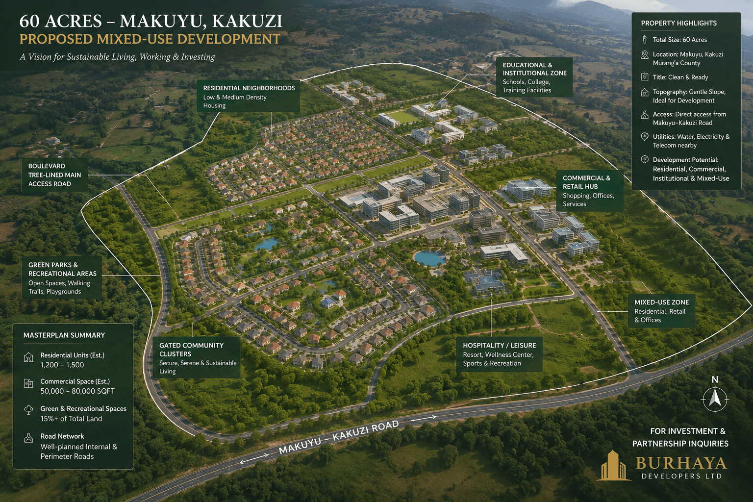
To illustrate how these corridor-level dynamics translate to the parcel level, consider a 60-acre site located in Makuyu, in the Kakuzi area of Murang'a County. We present this deliberately as a case study rather than a sales pitch — the more useful question is not "is this a good price?" in isolation, but "does a parcel with these characteristics fit an institutional acquisition thesis?"
Case Study Snapshot
| Location | Makuyu, Kakuzi, Murang'a County |
| Size | 60 acres |
| Current zoning | Agricultural |
| Potential | Future mixed-use residential development, subject to change-of-user approvals and county planning consent |
| Asking price | KES 4,500,000 per acre |
Scale
Sixty acres is large enough to support a genuine master plan — multiple residential zones, a retail component, community infrastructure, and internal road network — rather than a single subdivision. Parcels of this size are increasingly difficult to assemble intact within 30 km of Nairobi; their scarcity is itself part of the investment case, independent of any specific development programme.
Accessibility
The site's positioning in the Makuyu/Kakuzi area places it within the A2 highway catchment described above, benefiting from proximity to the Thika Superhighway terminus, the Kenol junction, and the ongoing Kenol–Sagana–Marua dualling works, without carrying the acquisition premium of sites directly abutting the highway in more built-up sections of the corridor.
Development Flexibility
Because the parcel is currently zoned agricultural and undeveloped, an acquirer retains full optionality over master plan design, phasing sequence, and eventual use mix — a materially different proposition from acquiring a smaller, already-subdivided or partially built site with legacy constraints.
Phased Construction and Long-Term Value
Scale of this kind allows a developer or JV partner to sequence capital deployment — infrastructure and a first residential/retail phase, followed by subsequent phases informed by market absorption — rather than committing full capital upfront. This phasing approach is standard practice among institutional land developers precisely because it allows early phases to be de-risked before later, larger commitments are made.
At KES 4 million per acre, the parcel is priced well below fully serviced peri-urban development land in more established corridors, consistent with its current agricultural zoning and the fact that infrastructure, approvals, and servicing represent future capital investment rather than sunk cost already reflected in the price.
Concept Master Plan
A master plan for a 60-acre mixed-use site in this location might reasonably contemplate the following zones:
Investment Considerations
Any acquisition of this nature should be preceded by structured due diligence. At minimum, investors should expect to verify:
- Land ownership and title. Confirmation of a clean, registered title and seller authority, via an independent Land Registry search and legal counsel engaged directly by the buyer.
- Infrastructure assessment. Realistic costing of road access, power connection, water supply or borehole development, and drainage/sewerage solutions.
- Environmental studies. Where required, an Environmental and Social Impact Assessment (ESIA) in line with NEMA requirements.
- Market analysis. Independent assessment of absorption rates for comparable products in the wider Thika–Murang'a corridor.
- Planning approvals. Engagement with Murang'a County's physical planning department on change-of-user requirements and zoning.
- Joint venture structuring. JV structures with an experienced local development partner as a route to participate without direct execution risk.
- Risk management. Realistic phasing and capital reserves for infrastructure cost overruns, absorption delays, and approval timelines.
None of these steps is unique to Makuyu; they are standard practice for any large land acquisition in Kenya. We highlight them here because the scale and long-dated nature of a 60-acre opportunity make disciplined due diligence — not optimism about the corridor — the primary determinant of investor outcomes.
Why This Opportunity Stands Out
Stripped of promotional framing, the parcel's characteristics align with several criteria institutional and sophisticated private land investors typically screen for:
- A contiguous parcel of institutional scale (60 acres), increasingly scarce within a two-hour drive of Nairobi.
- Location on an established, government-upgraded highway corridor rather than an unclassified access road.
- Proximity to a functioning economic base (Kakuzi, Del Monte, Kenol's administrative and trade functions).
- Current agricultural pricing on land with credible, though not guaranteed, potential for future rezoning.
- Flexibility to structure entry via outright purchase, phased acquisition, or joint venture.
Investors who identify infrastructure-led growth corridors ahead of the market — Thika Road ahead of Ruiru and Juja, the Nairobi Expressway ahead of Mombasa Road's re-rating — have generally captured disproportionate long-term appreciation relative to investors who entered after the re-rating had already occurred.
Market Pattern, Kenyan Peri-Urban CorridorsConclusion
The Kenol–Sagana–Marua highway upgrade, combined with Makuyu's existing rail asset, established agricultural economy, and administrative growth as part of Murang'a South, positions the corridor as a plausible candidate for a similar trajectory to Kenya's earlier growth nodes — while acknowledging, as with any emerging corridor, that timelines depend on continued infrastructure delivery, planning approvals, and market absorption.
For developers, family offices, REITs, land bankers, and diaspora investors evaluating where to deploy capital for the next cycle of Kenyan peri-urban growth, Makuyu warrants serious diligence rather than dismissal as a purely agricultural backwater.
Investors interested in reviewing the full investment memorandum for the 60-acre Makuyu parcel discussed in this article — including title documentation, indicative master plan, and JV structuring options — are invited to contact Burhaya Developers to request the memorandum and arrange a site visit.
Frequently Asked Questions
Where exactly is Makuyu located?
Makuyu is a town in Murang'a County, Kenya, situated along the A2 Nairobi–Nyeri Highway approximately 55–60 km from Nairobi CBD and about 18 km north of Thika town, immediately adjacent to Kenol.
Why are investors interested in Makuyu land right now?
Makuyu combines affordable land pricing, an established agricultural economy, and committed government infrastructure investment (notably the Kenol–Sagana–Marua highway dualling) — a combination that has historically preceded land value re-rating in other Kenyan peri-urban corridors.
Is the land in Makuyu currently zoned for residential or commercial use?
Much of the large-parcel land in and around Makuyu, including the case-study site discussed in this article, is currently zoned agricultural. Any transition to residential or mixed-use development requires a formal change-of-user application and Murang'a County planning approval.
How far is Makuyu from Nairobi and Thika?
Approximately 55–60 km from Nairobi CBD (roughly 60–75 minutes by road) and approximately 18 km from Thika town along the A2 Highway.
What makes a 60-acre parcel attractive compared to smaller plots?
Scale allows for a genuine master-planned, phased development — multiple use zones, internal infrastructure, and community amenities — and parcels of this size are increasingly scarce within reasonable commuting distance of Nairobi, supporting long-term scarcity value independent of any specific development outcome.
What infrastructure projects are improving Makuyu's investment case?
The Kenol–Sagana–Marua road dualling project, the completed Thika Superhighway terminating just south at Kenol, and Makuyu's existing rail station on the Nairobi–Nanyuki line are the primary infrastructure drivers.
Can diaspora investors purchase land in Makuyu?
Yes. Kenyan law permits diaspora Kenyans and, subject to applicable restrictions on freehold agricultural land for non-citizens, foreign investors to acquire land, typically via leasehold or through locally registered entities for certain categories of land. Investors should obtain independent legal advice specific to their citizenship status and intended structure.
What is the difference between land banking and development-ready land?
Land banking involves acquiring land primarily for long-term appreciation with limited near-term development activity, while development-ready land has progressed through zoning, approvals, and infrastructure planning to a stage where construction can begin. The Makuyu case-study parcel is currently better suited to a land-banking or phased pre-development strategy given its agricultural zoning.
What due diligence should investors carry out before purchasing land in Murang'a County?
At minimum: independent title verification at the Land Registry, confirmation of seller authority, infrastructure and access assessment, environmental review where applicable, and engagement with Murang'a County's physical planning department on zoning and change-of-user requirements.
How can investors get involved in the Makuyu 60-acre opportunity?
Interested investors can contact Burhaya Developers to request the full investment memorandum, review title and planning documentation, and arrange a site visit to the parcel and the broader Makuyu–Kenol corridor.
Your Partner for
Emerging Corridor Development
Identifying an emerging corridor is only the first step. Realising its value requires disciplined project management, planning expertise, and construction delivery.